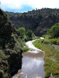
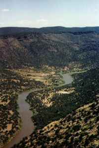
The most important of New Mexico's rivers are the Rio Grande, Pecos, Canadian, San Juan, and Gila. The Rio Grande is the third longest river in the United States. It is also the state's main river. It crosses the the entire state from north to south.
The continental divide also crosses the state of New Mexico. A fold in the earth's surface, the continental divide separates the direction in which North Amreica's rivers flow. East of the divide rivers drain into the Atlantic Ocean. Rivers west of the divide drain into the Pacific Ocean.
Whether east or west of the continental divide, New Mexico's rivers have supported life for hundreds of years. They have provided water for irrigation. Irrigation is the artificial watering of crops. People have irrigated crops in the Rio Grande Valley for more than 400 years.
The rivers have allowed people to irrigate crops in the places otherwise too dry for farming. This has been most true for hundreds of years of people living along the Rio Grande. Besides river water there is one more important source of water in New Mexico. This source is ground water. Ground water is water under the ground that people pump to the surface.
New Mexicans today use much ground water. Indeed, they get more than half their water for irrigation from ground water sources. An underground lake called the Ogalala stretches from southern New Mexico all the way up to Nebraska. Much of the ground water is taken from this lake.
https://www.geocities.com/Yosemite/Rapids/9755/NMrivers.html
The Pecos River flows from its origins in New Mexico through hot, dry, semi-arid landscapes in Texas. It is the largest Texas river basin that flows into the Rio Grande. As such, water use and hydrologic issues in the Pecos Basin will profoundly influence the future of the Rio Grande Basin.
The flows of the once great Pecos River have dwindled to a mere trickle due to natural and man-induced causes. Today, the upper reaches of the Pecos River in Texas now resemble a very poor quality creek rather than a river. If the integrity of the entire Rio Grande basin below the Pecos is to be improved and maintained, then it is crucial to protect water quality and quantity throughout the Pecos Basin in order to provide a viable level of in-stream flows.
Because water quality and streamflows have declined, the aquatic community of the Pecos River has been drastically altered. The Pecos Basin no longer has a healthy and diverse community of aquatic plants, invertebrates, microorganisms, fish and amphibians. Aquatic diversity has been negatively affected by changes in river hydrology, the destruction of riparian communities, oil and gas exploration activities, irrigation demands, long- and short-term droughts, damming of the river and the desertification of the upland watershed. These factors have allowed saltcedar and other introduced plant species to dominate the riparian systems within the watershed.
According to the data of International Boundary and Water Commission (IBWC), the Pecos Basin contributes an average of 11% of the annual streamflow into the Rio Grande near Amistad Reservoir (274 million cubic meters). The Pecos Basin also contributes more than 29% of the annual salt loading into Amistad Reservoir (0.54 million tons). Salinity levels in Amistad Reservoir exceeded 1,000 parts per million during 1998 and have fluctuated since then. It is important to control salt loading from the Pecos Basin if the goal is to maintain salinity levels of less than 1,000 ppm in Amistad Reservoir.

The Canadian River is a very long, major U.S. waterway that flows from its headwaters in the Sangre de Cristo Mountains in far southern Colorado border near Raton Pass, down through eastcentral New Mexico, then east across the Texas Panhandle into Oklahoma, where it drains a sizeable portion of that state before reaching its confluence with the Arkansas River just west of Fort Smith, Arkansas. Starting as a narrow river in New Mexico, the Canadian gains in size after entering Oklahoma, and becomes a waterway that, in places, is more than a mile wide. In New Mexico, the river has a navigable flow that is usually limited to years of above normal rainfall in the desert between Raton and Tucumcari. Its major tributaries include the Vermejo, Ute, Mora, Conchas and Cimarron Rivers, most of which offer paddlers really great whitewater runs when they flow. The geology of the Canadian River includes granite cliffs and canyons hear the headwaters and a deep sandstone canyon with historical ancient ruins between the Cornudo Hills to the west and the Kiowa National Grasslands to the east. Golden and bald eagles can be seen soaring high over the river valley, but few signs of civilization will be found along the river and its tributaries.
Located on the southern boundary of the Phoenix, Arizona metropolitan area and northwestern boundary of Pinal County, the Gila River Indian Community has committed to investing its revenues to increase economic development opportunities, education, housing, social services, public safety and other community services for Community members. But in turn, they have invested nearly $23.5 million in a 500 acre development for a commerce/business park, $125 million for a resort, including golf and related infrastructure, as well as $15.4 million into the Community's water and sewer improvements. This development is being developed around the Wild Horse Pass Casino off the Interstate 10 transportation corridor, at the southern gateway into the Phoenix metropolitan region. Its location also is adjacent to two of the three of the highest median income areas in the Arizona and to Chandler's Silicon Desert, home of Intel's largest Fab plant.
The Community's location offers many opportunities with the existing transportation infrastructure to move your products or bring your employees to your work site. With the Interstate 10 transversing the Community, with access to the Union Pacific Railroad transcontinental lines easily accessible from within the Community, and as a member of the Williams Gateway Airport Authority, air transport is close by as well through Phoenix's Sky Harbor International Airport.
If your firm is interested in growing in a thriving market, locating to the Gila River Indian Community maybe your answer. Contact the Gila River Indian Community Economic Development Department. Let us give your firm the opportunity to be a player within our Community.